CCTV News: According to China Weather Network, from March 2 to 3, the rain and snow in the central and eastern regions will enter the strongest period of the process. Shaanxi, Henan, Shandong and other places will experience the transition of rain and snow. When rainfall in the south, you must be vigilant against strong convective weather. As the cold wave moves southwards in a large scale, the central and eastern regions will also experience significant cooling from north to south. The Jianghuai and Jiangnan will become the core areas for cooling down. The cumulative drop in the highest temperature in many places can reach more than 20℃, and the cooling and heating reversal is violent.
The north is mixed with rain and snow, and there is heavy snowfall in Shaanxi and Shandong, and the south needs to be vigilant against strong convection. Yesterday, due to the cold wave, the rain and snow weather in the central and eastern regions gradually spread. Monitoring shows that light to moderate snow or sleet occurred in some areas such as the Yili River Valley in Xinjiang and the Tianshan Mountains, central and northern Qinghai, central and eastern Gansu, Ningxia, northern Shanxi, northwestern Hebei, northern Jilin, southeastern Heilongjiang and eastern Tibet, and local heavy snow or blizzards such as Haixi and Huangnan in Qinghai, Zhongwei and Wuzhong in Ningxia. Moderate to heavy rain occurred in some areas such as southern Shaanxi, southeastern Shanxi, southwestern Hebei, southeastern Shandong, central and northern Henan, western Hubei, northern Chongqing, and northeastern Sichuan, and local heavy rainstorms in Shiyan, Hubei, Dazhou, Sichuan, and northern Chongqing.
Today and tomorrow, as the cold wave moves southward and the warm and humid air flow converges violently, precipitation in the central and eastern regions enters the strongest period of the process. With the cooling down, rain-turning snow will occur in the eastern part of the northwest region, western and southern North China, Huanghuai, Jianghan, Jianghuai and other places, among which the precipitation in Shandong is complex. The day after tomorrow, there will still be large-scale rainfall in Jiangnan, South China and other places.
The Central Meteorological Observatory predicts that today, there will be light to moderate snow or sleet in some areas of western Inner Mongolia, southern Xinjiang, eastern Tibet, central and eastern Northwest, central and western North China, Huanghuai, northern southwest, and northern southwest. Among them, there will be heavy to moderate snow or sleet in some areas of Hetao, Inner Mongolia, mountainous areas of southern Xinjiang, eastern Tibet, central and northern Ningxia, northern Shaanxi, central and eastern Shandong, and southern western Sichuan Plateau. There will be light to moderate rain in some areas of the southeastern part of the northwest region, northern North China, eastern and western Huanghuai, Jianghuai, Jianghan, central and northern and western Jiangnan, eastern and southern Southwest region, among which there will be heavy rain in some areas of eastern and southern Shandong, southern Henan, northern Anhui, northern Jiangsu, southern Hubei, northern Hunan and western Hunan, and eastern Guizhou.
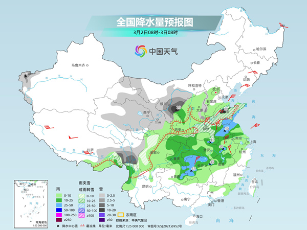
Tomorrow, there will be light to moderate snow or sleet in some areas such as western Inner Mongolia, Xinjiang's Ili River Valley and western southern Xinjiang, southeastern Tibet, Gansu Hexi, eastern and southern Northwest, most of the Huanghuai, northern Anhui, eastern and western Jianghan, among which there will be heavy to moderate snow in some areas such as southern Shaanxi, central and southern Shandong, eastern and southern Henan, northern Anhui, northern Hubei and western Hubei. There will be light to moderate rain in some areas such as most of the Jianghuai River, most of the Jianghan River, south of the Yangtze River, eastern southwest, southern China, and Taiwan Island, among which there will be heavy rain in some areas such as southern Anhui, southern Zhejiang, and northwestern Fujian.
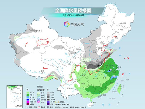
The day after tomorrow, light snow or sleet will be found in some areas of northwestern Inner Mongolia, Liaodong Peninsula, southern Xinjiang Basin and northern Xinjiang Basin, southeastern Tibet, central northwest, southern Gansu, eastern Huanghuai, and northern western Sichuan Plateau. Among them, moderate snow will be found in some areas of Xinjiang along the Tianshan Mountains and southern Xinjiang Basin, southeastern and western Tibet. There will be moderate to heavy rain in some areas of eastern Jiangnan, northwestern Fujian, northeastern Guangdong, and most of Taiwan Island, among which there will be heavy rain in some areas of central and northern Taiwan Island.

Tip everyone, this round of precipitation process is mixed with rain and snow in many places in the north, and heavy snow may occur in some areas of Shaanxi, Henan, Shandong and other places. The public should pay attention to preventing the adverse effects of slippery roads, snow accumulation, and reduced visibility on transportation. It should also be noted that the base temperature in many places in the south is high in the early stage and there is a high convection energy. When raining in Jianghuai, Jiangnan and Guizhou, you should also be wary of strong convective weather such as short-term heavy rainfall, thunderstorms and strong winds.
The central and eastern regions have seen a significant cooling from north to south, and the cold and warmth in many places in the south have been severely reversed
In addition to large-scale rain and snow, the cold wave will also create a severe cooling for the central and eastern regions. In the next three days, the temperature in the central and eastern regions will drop by 6 to 10℃ from north to south. Among them, the temperature in southern North China and most areas south of North China will drop by 12 to 16℃, and some areas will drop by more than 18℃; on the morning of the 4th, the lowest temperature 0℃ line will press south to the Jianghan to the Huaihe area. This morning, the Central Meteorological Observatory continued to issue a yellow warning for cold waves.
From the cooling process, today's cooling mainly occurs in the eastern part of the Northwest region, North China and Huanghuai. Tomorrow, the Jianghuai, Jianghan and Jiangnan regions will join the cooling "group chat", and the cooling area will be further promoted to South China the day after tomorrow.
Due to the sharp increase in temperatures in various places in the early stage, the maximum temperature drop in this process was particularly obvious, and the cumulative decline in most areas is generally above 10℃. Among them, the cooling amplitude in North China is mostly around 15℃, the Huanghuai River is between 15 and 20℃, and the Jianghuai River and some areas in Jiangnan can reach above 20℃.
Before the cold wave arrives, the highest temperature in Hangzhou today will reach 30℃, which will hit 30℃ for the first time this year, which may break the local record of the earliest 30℃ and will drop to 10℃ tomorrow; the highest temperature in Hefei today can reach 24℃, and will plummet to 3℃ tomorrow, with a huge contrast between cold and warm.
Tip everyone, the temperature fluctuates a lot during the alternating winter and spring. It is recommended that the public pay attention to temperature changes, adjust their clothes in time, and beware of the occurrence of respiratory system, cardiovascular and cerebrovascular diseases.