
CCTV News: According to China Weather Network, today and tomorrow (April 15th to 16th), the central and eastern regions will heat up and enter the fast lane, and the warmth of the North China, the Huanghuai River and other places will return, and many places such as Beijing, Tianjin and Hebei will usher in the first "30℃+" this year. At the same time, precipitation in the north and south will increase from tomorrow. Overall, rain and snow in the north will pass by in a hurry, while the south needs to be vigilant against strong convective weather.
Most of the central and eastern parts of the country have significantly heated up, and the Huanghuai River in North China will have a large area above 30℃. Since April 11, strong winds have occurred in most areas of the central and eastern parts, which have the characteristics of a wide range of influence, a long duration, and many sites that break through extreme values. Yesterday, although the wind in North China and Huanghuai areas weakened, the gusts of the day still reached level 7 to 9. As the cyclone moved southeast and the intensity weakened, the wind in the above areas also decreased one after another at night.
As the strong winds in North China, Huanghuai and other places weaken, most of the central and eastern regions will usher in a significant warming today and tomorrow, and areas with the highest temperature above 30℃ will increase significantly. Today, Beijing, Tianjin and Shijiazhuang will all hit 30℃ for the first time this year; tomorrow, central and southern Shaanxi, southern Shanxi, southern Hebei, eastern and eastern Shandong, Henan, western Hubei, northern Anhui, northern Jiangsu and other places will enter "group chats" with temperatures above 30℃, and some areas may also experience high temperatures of 35℃ or above. Among the big cities, Zhengzhou may now have the first high temperature this year, which will also be the first high temperature in the northern provincial capital this year, and may also break the earliest high temperature daily record of the northern provincial capital.
As the maximum temperature rises rapidly during the day, the temperature difference between day and night in various places will gradually widen at night. The temperature difference between day and night in the local area may exceed 20℃, and warmth is still needed in the morning and evening. China Weather Network recommends that everyone adopt the "onion style" dressing method to facilitate the timely addition and reduction of clothes and be careful not to catch a cold.
The development of rainfall in the north and south will increase from tomorrow. Jiangnan, South and South China need to be vigilant against strong convective weather
Yesterday, rain and snow in Northeast China and other places weakened significantly. Monitoring shows that light to moderate snow or sleet occurred in some areas of southern Qinghai, eastern Tibet, and heavy snow, and some areas of heavy snow; light to moderate rain or sleet occurred in some areas of Yili River Valley, eastern Jilin, and other areas of Xinjiang.
Today, the rain and snow process in the Northeast will weaken and end, and most of the country will maintain a sunny and less rainy weather pattern. Starting tomorrow, precipitation in the north and south will increase again, and rainfall in the eastern part of the southwest region, Jiangnan, South China and other places will be frequently "check in" in the next week.
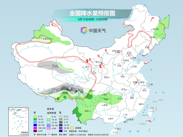
The Central Meteorological Observatory predicts that today, there will be light to moderate snow or sleet in some areas along the Tianshan Mountains in Xinjiang and the mountainous areas in the southern Xinjiang Basin, eastern and southern Tibet, western Qinghai, western Sichuan Plateau, and other areas. Among them, there will be heavy to moderate snow in some areas in northeastern Tibet and southern West Sichuan Plateau. Light to moderate rain will occur in some areas such as the eastern part of the Northeast, southeast Tibet, eastern and southern Southwest, and western Hunan.
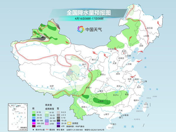
Tomorrow, there will be light to moderate snow or sleet in the high-altitude areas in northern Xinjiang, northeastern Inner Mongolia, eastern and southern Tibet, eastern and southern Qinghai, western Sichuan Plateau, etc., among which there will be heavy to blizzards in the high-altitude areas in northern Xinjiang. Light rain will occur in some areas such as northern Xinjiang, central and eastern Inner Mongolia, southeastern Tibet, southern Gansu, western Sichuan Basin, most of Guizhou, western Yunnan, and central and western Jiangnan, among which moderate rain will occur in some areas such as northern Xinjiang, southern Sichuan, central Guizhou, and western Hunan.
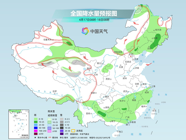
The day after tomorrow, there will be light to moderate snow or sleet in northeastern Inner Mongolia, northwestern Heilongjiang, central and northern Qinghai, western Gansu and other areas. There will be light rain in some areas in eastern Xinjiang, eastern and northwestern Inner Mongolia, most of the Northeast, southern Sichuan, southern Guizhou, most of the Jiangnan, and most of the South China.
China Weather Network reminds that heavy rainfall in the south will mainly occur in Jiangnan, northern South China and eastern Guizhou in the next week, and may be accompanied by strong convective weather when rainfall is present. It is recommended that the public pay attention to the approaching forecast and warning information and minimize going out when strong convective occurs.